Windhoek, Namibia
Honest estimates from sparse data.
All models are wrong, but some are useful.
— George Box
Missing decades. Failing sensors. Sparse records. I build data pipelines and statistical models that remain correct anyway - auditable, versioned and honest enough to say "we do not know" when that is the answer.
About

I am a quantitative analyst based in Windhoek, Namibia.
My Honours research — published in Wind (MDPI) — found that spurious sensor data had inflated Namibia's extreme wind estimates by 35%. That project taught me my real interest: not climate science as a cause, but the craft of building methods that remain correct when data is sparse, sensors fail, and the client needs a number by Friday.
Work & projects
Namibia Station Monitor
A living data-quality audit of every Namibian weather station in the NOAA global archive. Recomputes a Data Quality Score (DQS v1.0) for all 56 stations on the 1st of each month via automated pipeline. Confirms Lüderitz present in ISD metadata since 1949, returns HTTP 404 in GHCND. Citable dataset: Igulu (2026), DOI 10.5281/zenodo.21229782.
The Namibian station audit: what the global climate archive actually contains
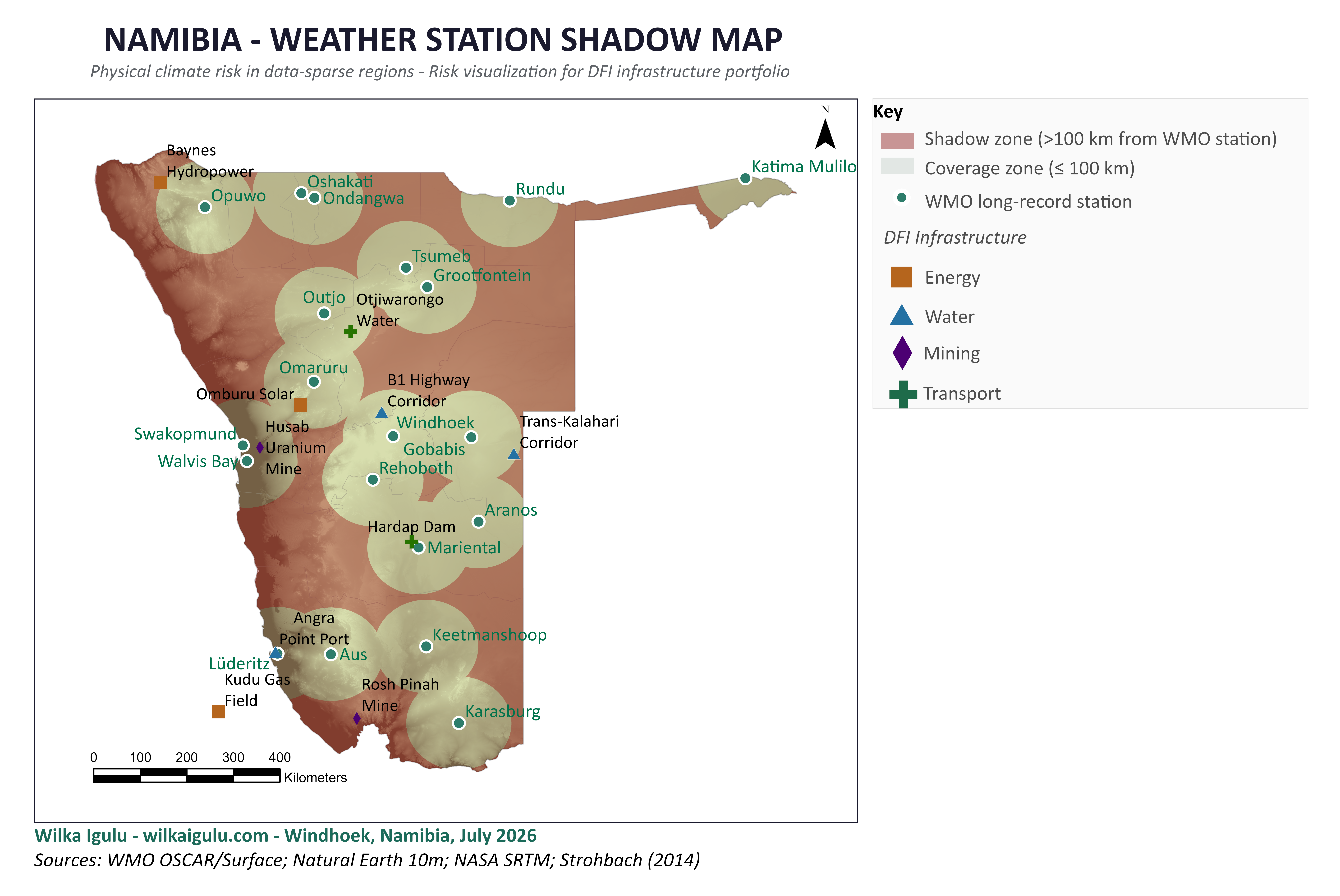
I pulled and quality-scored every Namibian record in NOAA's global daily archive. Three of ten stations reach the present day. Ondangwa is missing the 1990s. Lüderitz is not in the archive at all. The audit behind the shadow map and the article below.
Modelling Wind Speed Extremes Using Extreme Value Theory: A Case Study for Namibia
Identified that quality control - not model choice - was the dominant source of error in Namibia's extreme wind estimates. Removed 70 spurious AWS records (0.24% of observations) that were inflating 100-year return levels by 35-45%. Produced the first station-level GPD return-level estimates with profile-likelihood uncertainty bounds for six Namibian stations.
doi.org/10.3390/wind6030040 ↗
Namibian Climate Risk Sandbox
An open, reproducible pipeline from raw NOAA station records and CMIP6 projections to boardroom-ready physical risk assessments for a real Windhoek asset, the Goreangab Water Reclamation Plant. Station audit and CMIP6 bias-correction phases complete; extreme value and financial layers in build on a published schedule.
SACRF - Sparse-Adaptive Climate Risk Framework
Built on peer-reviewed extreme value research (Wind/MDPI, 2026). A Bayesian engine for honest climate-risk estimation in data-scarce African markets, where prior precision adapts to station-level data quality so that short records and long records are treated with appropriate uncertainty. Financial translation layer and pre-registered calibration experiment in design.
Data visualisations
Namibia Station Monitor - live DQS feed
56 Namibian weather stations scored monthly by Data Quality Score. Filter by usability tier or GHCND status. Lüderitz confirmed absent from the global daily archive despite ISD registration since 1949.
Skills
Production
Research
Building
Currently reading
Writing
Why Namibia's weather stations are a development finance problem
Twenty long-record stations, 825,000 km², a shadow map covering 64% of the country. What that means for infrastructure lending in southern Africa.
Currently
- Building The Namibian Climate Risk Sandbox, an open pipeline from raw station data to climate-adjusted NPV and the SACRF working paper behind it
- Education BSc Applied Mathematics and Statistics — NUST, May 2025 · BSc Honours Applied Statistics — NUST, May 2026
- Practicing Python ETL pipelines · Financial Markets (Yale / Coursera)
- Reading Knaflic (2015) — Storytelling with Data
Contact
I take on selective consulting work in data pipeline architecture, statistical sampling, and risk quantification. For project inquiries or professional opportunities, reach out directly.